Lake District Waterfall Walks
Like walks? Love waterfalls? We’ve compiled a list of some of our favourite waterfall walks in the Lakes. As well as breath-taking scenery, some of these walks even offer the opportunity of a refreshing wild-swim in a spectacular waterfall pool. What could be better after a hot summer’s hike to a stunning waterfalls than a cooling dip in a crystal clear turquoise pool when you get there? Not much we say.
So pack your towels and your picnic and get ready for a great day out chasing waterfalls in the Lake District National Park.
Coppermines Waterfalls, Coppermines Valley, Coniston
Swimming? Yes 2 hours 3.2miles


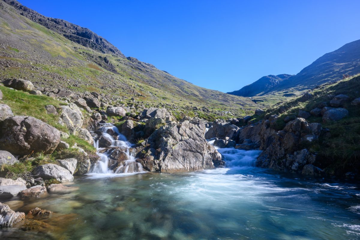
Well, we could hardly compile a waterfalls walks list without including our own incredible falls in it. This circular walk takes in several stunning waterfalls on route, including the “secret” waterfall pool in Red Dell Beck beneath the Coniston Fells.
From The Bluebird Car Park in Coniston village, head north-west from the Ruskin Museum along Coppermines Lane (lane starts between the Black Bull and village Co-op). The lane soon bears left and becomes an unmade road. Continue uphill on the track, passing over a cattle grid. Before long, you’ll see your first waterfalls below you on your left. Go past Miner’s Bridge without crossing it. Your first opportunity for a swim is just after the bridge where it’s possible to scramble down to Church Beck.
From Miner’s Bridge continue ahead and uphill towards The Coppermines Mountain Cottages. At the cottages, go past the waterwheel and cross the wooden footbridge with the mine truck on ahead. Follow the path uphill alongside the beck, which should now be on your left. You’ll see a stone tower, part of the old copper mining works ahead, which is what you are aiming for. Follow the path alongside the waterfalls, there are more mountain pools for taking a refreshing dip in this section of the walk.
As the path levels out at Red Dell, cross the wooden footbridge over the beck then take the path on your left which takes a level sweep around the fellside below Tongue Brow. As you approach the other side of Tongue Brow, the path begins to descend under some crags. Head downhill then turn right towards the water treatment plant. Before reaching the plant, take the mountain road sweeping left, back towards Coppermines Mountain Cottages and the YHA. Below you on your right, are more waterfalls and another pool for swimming, with a spectacular backdrop of Coniston Old Man behind you.
Stay on the mountain track as it sweeps right, then at Miner’s Bridge, this time cross the bridge and turn left to head back into Coniston. The final waterfalls of this walk are on your left, and there is a final pool for swimming in a wooded section as you descend. The path emerges at Dixon Ground, then The Sun Inn. Turn left at The Sun to return to the village centre.
Sourmilk Gill, Seathwaite, Borrowdale
Swimming? Yes 2.5 hours 4.3 miles


This walks starts at National Trust Car Park in Seatoller. It takes in the picturesque valley floor towards Seathwaite before ascending a steep, pitched stone footpath alongside Sour Milk Gill. There is a pool for swimming as you ascent the falls, as well as a small, swimmable “infinity” pool at the top of the falls.
From Seatoller Car Cark, turn left to head back along the B5289 for 0.4 miles. At the row of houses, take the lane on your right signposted to Thorneythwaite Farm. After another 0.4 miles, the lane curves to the right towards the farm. Leave it through a gate on your left and follow the wall to continue heading in a southwest direction. The path rejoins a wider, grassy track which, after around a mile, will bring you to Seathwaite Farm. Turn right towards the main farm building. On your left, a signposted footpath passes underneath some farm buildings and emerges on a path enclosed by dry stones walls on each side. Follow the lane to the wooden footbridge and cross it. Take the path on the left heading uphill alongside a stone wall. Cross the wall via the stile and continue on the path uphill, which zig zags its way up the lower slopes of Base Brown. After a time, the path turns to bring you closer to the gill and presents you with an impressive pool under a thundering waterfall. You can scramble down for a dip on continue along the path uphill
Return down the waterfalls but rather than crossing the footbridge back to Seathwaite Farm, turn left to take the footpath following the river. At Seathwaite Bridge follow the road back to Seatoller.
Sourmilk Gill, Easedale Tarn, Grasmere
Swimming? Yes 2.5 hours 4.6 miles


In Grasmere Village, take Easedale Road, signposted to Easdale Tarn. After around 15 minutes, a wooden footbridge, opposite a red post box in the wall, leads to a footpath on your left. Cross the bridge and follow the path which itself follows the beck on your right. The path begins to climb the fellside and before too long you’ll reach your first pool, beneath a lovely waterfall, perfect for a wild swim if you’re in the mood. The path continues uphill to Easdale Tarn, another beautiful place for a wild swim, picnic or simply to soak up the majestic views.
A footpath circles around the tarn or there are paths up into the surrounding fells including Tarn Crag, should you wish to continue. If not then, once you’ve enjoyed your time at the serene Easdale Tarn, you can either retrace your steps back to Grasmere or return via an alternative route shown on the map. This route begins on the opposite side of Sourmilk Gill from which you ascended.
The path initially follows the river before veering north as it descends, eventually bringing you to Far Easedale Gill. Cross the gill at the footbridge then turn right to follow the gill in a southeasterly direction. The path leaves the gill and follows a drystone wall (on your right) as it skirts the lower slopes of Helm Crag (The Lion and The Lamb). The path eventually brings you to a collection of houses and back on to Easedale Road. Turn left along road to cross the centre of a wide grassy enclosure and stay on Easedale Road to reach Grasmere Village and your starting point.
Galleny Force and Black Moss Pot, Borrowdale
Swimming? Yes 2 hours 4 miles (2 miles each way)


Despite its remoteness and its wild, rugged setting surrounded by soaring mountains in an isloated valley, the walk to Black Moss Pot from Stonethwaire in Borrowdale is relatively easy, without any major challenges.
From the tiny Stonethwaite village in Borrowdale (there is no parking in Stonethwaite itself but there is limited layby parking on the lane approaching the village off the B5289), take the lane on the right of the red phone box, go past The Langstrath Country Inn, then bear right then left as the lane comes a wide track. Head southeast on the lane, with Stonethwaite campsite on your left. After around 18 minutes, or 0.8 miles, you’ll reach Galleny Force Waterfalls, a beautiful spot to stop for photos, snacks or both. After the falls the path turns right to begin heading in a southerly direction, alongside Langstrath Beck which will be on your left. Keep heading south on the footpath. Around 1.2 miles from Galleny Force Waterfalls you’ll reach Black Moss Pot, a narrowing in the river creating a deep natural pool in encased in dramatic rock. An incredible location for a wild swim.
Once you’re ready, retrace your steps back to Stonethwaite village.
Wasdale Head, Emerald Pools
Swimming? Yes 2hours 15mins 3.7 miles (1.9 miles each way)

This walk takes in some stunning waterfall pools in one of the most dramatic and awe-inspiring Lake District locations, Wasdale Valley. Nestled between the soaring slopes of Great Gable and the Scafell Massif, the Wasdale “fairy” pools are a true Lake District hidden gem.
From Wasdale Head, take the lane leading to St Olaf’s Church, the smallest church in England. Continue along the lane towards the imposing pyramid shaped Great Gale ahead. Follow the path as it bears left through Burnthwaite Farm buildings. As it leaves the farm behind, the path follows a dry-stone wall on your right, heading west and before long begins to run alongside Lingmell Beck. Cross the footbridge, immediately after which you’ll see a path brand off on your left taking a steep approach towards Great Gable. Ignore this and continue ahead. After 0.3 miles, or around 10 minutes, after the footbridge the path divides again. The left brand climbs the southern slopes of Great Gable towards Styhead Tarn, the right continues to follow the route of the beck – take the path on the right. Stay on the path as it follows the river and eventually your reach the the Fairy Pools, a set of turquoise pools in this stunning setting. A little further uphill, you’ll reach The Emerald Pool, the largest natural pool in this section of the beck. Take care if climbing down the rocks into the pool.
Return via the same route.


