Best 5 Routes Up Scafell Pike


For many visitors to the Lake District, climbing Scafell Pike, the highest mountain in England, is high on the to do list. Its lofty status as the number one fell in many English classification categories makes it one of the most popular walks in the Lakes. Well who doesn’t want to be able to say they’ve conquered England’s highest peak?
But which Scafell Pike route is the best? Which route is the easiest (is there an easy way?!) And which is nearest to your accommodation with the least amount of driving required? To answer all your Scafell Pike questions, we list the five best Scafell Pike routes to walk up the Lake District’s most famous fell of all.
Where is Scafell Pike?
At a towering 978m, Scafell Pike is hidden away in the western Lake District in Cumbria. The Scafell massif is a horseshoe-shaped collection of mountains and includes Broad Crag, Ill Crag, Lingmell and Scafell, which is just across the col from Scafell Pike. These fells sit at the head of Wastwater, or Wast Water – the deepest lake in England – separating Wasdale from the Langdales, Borrowdale, Buttermere and Ennerdale.
The Scafell Pike location you need depends on where you want to walk from. You can access the mountain from four different valleys so there’s no one location where it’s easiest to glimpse the peak. Depending on how long you want to trek for, how fit you are and how much time you have, your Scafell Pike route may start from either Eskdale, Langdale, Borrowdale or Wasdale. Each has its own endearing qualities so first decide where you want to stay. Then figure out the logistics of your Scafell Pike walk.
Quick Facts about Scafell Pike
Where is Scafell Pike?
In the western Lake District National Park, within the county of Cumbria, which is in the northwest of England.
How high is Scafell Pike?
The elevation of Scafell Pike is 978m.
How long to climb Scafell Pike?
The quickest route to climb Scafell Pike is from Wasdale Head. This will take around 3-4 hours to summit and return along the same path. Climbing Scafell Pike from Langdale, Borrowdale and Eskdale will take between 4-8 hours depending on route.
What are Scafell Pike’s credentials?
It’s the highest mountain in England, the highest Wainwright in the Lake District, the highest Marilyn in England, the highest Nutall in England and the highest Hewitt in England!
Climbing Scafell Pike
Whichever route you choose, plan ahead, check the weather forecast – and be prepared to reschedule your day out for better weather! Wear suitable shoes/boots and clothing, bring plenty of water (and snacks, lots & lots of snacks) and ensure you have everything needed to stay safe in the fells.
Layers, waterproofs, a map and a compass are all essential items for your Scafell Pike hike. Make sure you know how to use a compass and read a map so you know which Scafell Pike trail you’re on and how to return to your starting point should the weather turn.
Scafell Pike weather is notoriously changeable – in fact, the whole Lake District is known for its unpredictable weather. Pack appropriately and check the appropriate mountain weather forecast before heading into the Scafell Pike mountain range.
Our Favourite Scafell Pike Routes
On Scafell Pike, difficulty ratings vary for the different routes. The short sharp climb of the Scafell Pike Wasdale route is hailed as the easiest route up Scafell Pike but there’s no ‘easy’ route as such! It’s the highest mountain in the country after all. All hiking trails include steep ascents, some feature scrambling in places and descending on loose and varied terrain.
The Scafell Pike Corridor Route is more scenic but much longer and routes up Scafell Pike from Langdale offer an escape from the crowds but can be trickier to access the starting points.
The following routes each offer a wonderfully unique journey to the top of Scafell Pike. Read on to find out which will best suit you, or try all five for yourself, and make an excuse to keep on coming back to this remote corner of Cumbria.
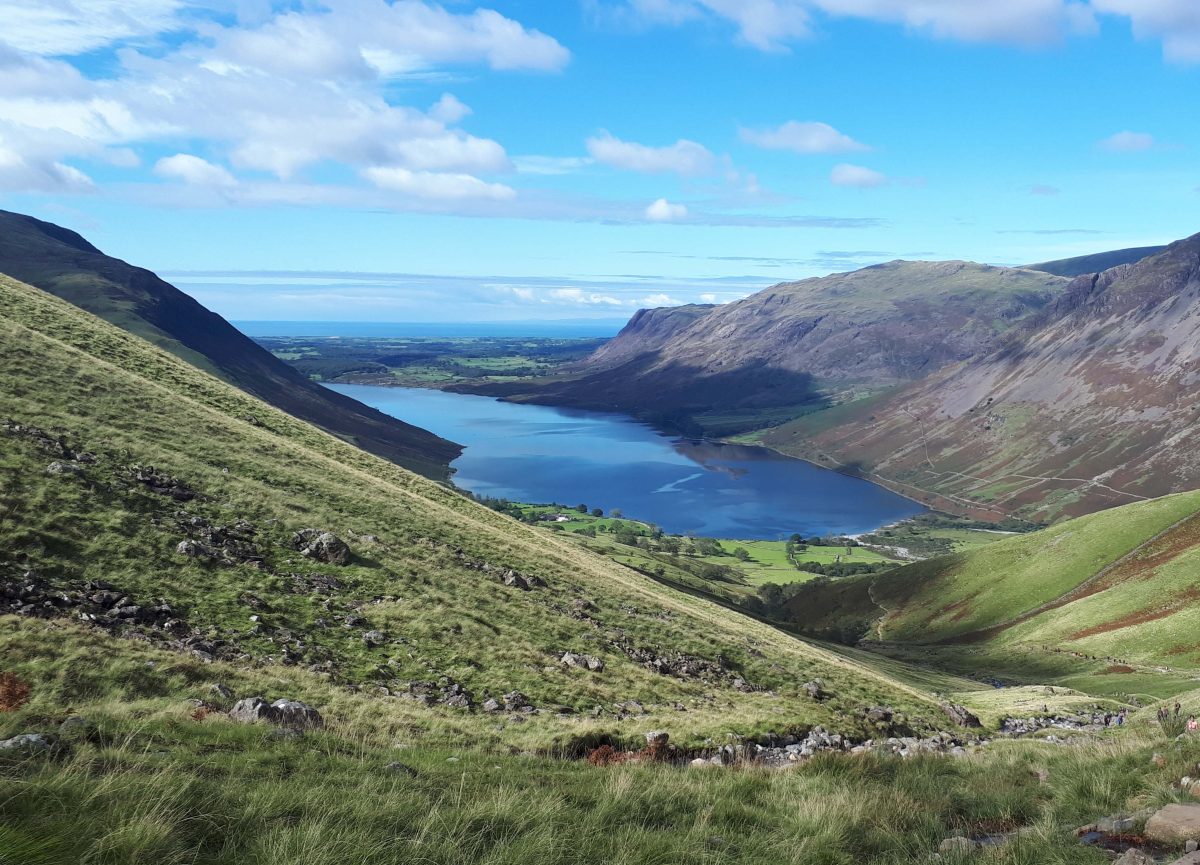
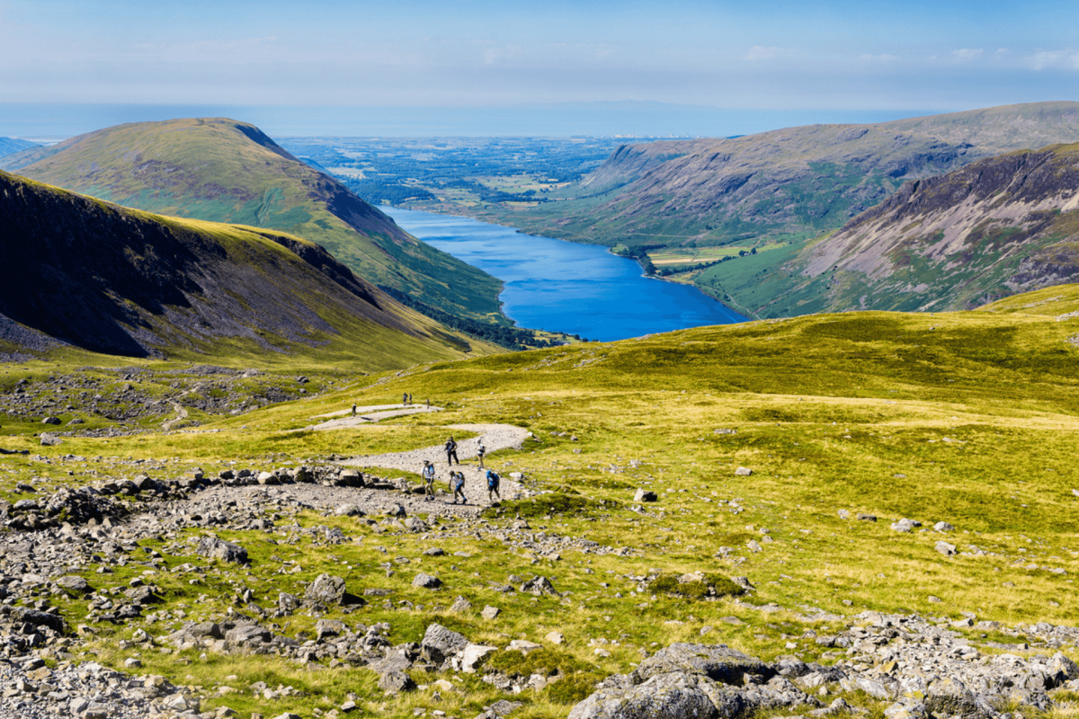
1. Scafell Pike from Wasdale Head – The Most Direct Route
Approximately 4.2km / 2.6mi one way, or 8.4km / 5.2mi out and back

The shortest, most straight-forward (and most popular) route up Scafell Pike is from Wasdale Head. The drive is an amazing experience and impressive in its own right – taking in breathtaking views of Wastwater, the deepest lake in England, as you weave your way towards the tallest mountain in England at its head.
Climbing Scafell Pike from Wasdale is a fairly simple route to follow. From the National Trust Car Park at Wasdale Head, head out and up towards Lingmell Gill. The pitched stone path follows the gill steeply uphill and is straightforward to follow.
As the path bears left to leave the gill behind, take the left-hand fork to continue up the main path (the right-hand fork leads up to Broad Stand and Mickledore via scree and isn’t recommended in poor weather or for less experienced walkers).
Stone cairns mark the route and are pretty easy to follow in good weather. In low cloud, try to ensure you’ve spotted the next cairn before setting off from the one you’re at, although this is no substitute for navigation using a map and compass. The Scafell Pike summit comes into sight, and from here you can enjoy truly spectacular views across Great Gable, the Irish Sea and Morecambe Bay. Enjoy the moment and make the most of the selfie opportunities before descending along the same route.
The summit of Scafell Pike is boulder-strewn and can be rather confusing – particularly in mist or low cloud. Stone cairns mark the various paths from the summit down to the valleys below. When descending, take extra care to choose the correct path to avoid ending up in the wrong valley and miles from your car! Follow Scafell Pike directions using GPS on your phone or with a waterproof map and a compass, checked periodically to make sure you’re heading in the right direction. Navigating using a map is the most reliable method for finding your way through the fells but GPS is more convenient for quickly checking your current location.
2. Scafell Pike From Seathwaite via The Corridor route and Styhead Tarn
Approximately 14km / 8.7 mi one way, or 28km / 17.4mi out and back

The Corridor Route Scafell Pike walk begins at the end of Seathwaite Road in Borrowdale. All the paths up Scafell Pike are incredibly scenic, but the Corridor Route is particularly beautiful.
Pass through the farmyard and exit through a gate at the far side. Follow this rough track around the edge of one enclosure and southwards into the valley, where you’ll see a beck on your right.
Pass through a couple more gates and swing right to cross Stockley Bridge.
Go through the gate ahead and follow the path as it rises to another gate. Go through the gate and immediately turn right to cross a beck and continue on the path rising in a sweeping arc above the ravine.
The trail now swings southwest and climbs steadily. Eventually the gradient eases and the path follows alongside Styhead Gill. Cross the gill at the footbridge then bear left. Styhead Tarn will soon come into view.
You’ll spot a mountain rescue stretcher box at Sty Head. As you near it, bear left to cut across the lowest point, crossing wet ground via stepping stones. Continue over the grass and swing left to round a knoll and pick up a faint path behind it. The Corridor Route begins across the depression of Spout Head.
Reaching the Corridor Route just before Skew Gill, turn right, cross the gill and climb the bank on the other side. Bearing left, climb further and join the stone pitched path. After a short rise bear right and climb less steeply southwards, following the obvious trail. The towering crags above and to the left belong to Great End.
Rounding a corner, the infamous ‘rocky step’ appears. At the bottom of the step continue to the head of the ravine keeping level, without descending into it. Cross the open ground and swing right below Broad Crag. Ignore the path off to the left and continue right.
Rounding another corner cross the head of the dramatic Piers Gill. Lingmell Col is now ahead and above. Keep left and note the cairns marking the way over rocky ground to the col. Remember the last cairn, as you will need it as a landmark on the return journey.
On Lingmell Col, turn left and join the path coming up from Wasdale.
The route is now loose scree over boulders with a succession of cairns marking the way. The edge of the plateau is marked by a substantial cairn; Scafell Pike summit finally comes into view across the final boulder field.
Retrace your steps for the return journey carefully to avoid finding yourself in the wrong valley!
3. Scafell Pike From Eskdale via Great Moss
Approximately 8.5 km / 5.3 mi one-way, or 17km / 10.6 mi out and back

If you’re looking to walk up Scafell Pike without the crowds, this could be the route for you. Upper Eskdale is a remote but staggeringly beautiful place – where the highest peaks in England tower around you like a cathedral of mountains.
Walking Scafell Pike from Eskdale begins by the red phone box in Brotherikeld, at the foot of the Eskdale side of Hardknott Pass. Take the lane heading north from the phone box. At the farm take the footpath which roughly follows the River Esk.
With the river on the left continue up into Upper Eskdale valley. After approximately 3km and just past a sheep enclosure, cross the footbridge over Throstle Gill, with the diminishing River Esk still on your left, to continue up towards Great Moss.
At the open and dramatic expanse of Great Moss, cross the river again to begin the Scafell Pike ascent towards Broad Stand. The path roughly follows How Beck with the two highest mountains in England on either side of this rugged route: Scafell on your left and Scafell Pike on your right.
Once at Broad Stand, which divides the two Lakeland giants Scafell and Scafell Pike, all of a sudden, magnificent views down to Wasdale and Wastwater appear.
From Broad Stand turn right and follow the cairns across the boulder field to Scafell Pike Summit.
4. Scafell Pike From Langdale via Rossett Gill & Esk Hause
Approximately one-way distance: 9.3km / 5.8 miles
For those staying in or around Coniston (you lucky people you), or in the stunning Langdale Valley itself, then the nearest starting point for Scafell Pike is from Great Langdale.
From the Stickly Ghyll National Trust Car Park head west. The path initially follows the flat Mickleden Valley floor with Mickleden Beck on your left for 3km before veering left over a footbridge and climbing steeply into Rossett Gill.
Following the pitched stone path, you’ll quickly gain height as you head upwards towards Angle Tarn. Should you need to pause to catch your breath (as we certainly did), you’ll see stunning views down the beautiful Langdale Valley and the prominent Pike O’Stickle.
As you near the end of the steepest part of the climb, you’ll see Rossett Pike (651m) on your right (Wainwright Baggers may wish to take a short diversion here). Angle Tarn appears ahead with the path curving to the right of the tarn.
Continue ahead to Esk Hause where the path joins up with others and begins to head west then southwest across the rocky, barren landscape of the Scafell massif. Continue towards Ill Cragg via a steep scramble then beyond via Broad Crag Col ridge, with stone cairns marking the way, and finally on to Scafell Pike summit itself.
Return via the same route to find your way back to your starting point.
5. Scafell Pike From Langdale via Bowfell (902m), Esk Pike (885m) and Great End (910m)
Approximately 10.1km / 6.3 mi one-way, or 20.2km / 12.6mi out and back

For experienced walkers and dedicated Wainwright baggers, this route takes in not only Scafell Pike, but three other hefty Wainwrights – all of which fall within the highest eleven Wainwright fells. It’s a long day – but one you’re likely to never forget!
Throughout the walk take in spectacularly rugged mountain scenery as you journey from the lush, green valley floor to the rocky, grey summit of the highest mountains in England.
Starting in Langdale near the Old Dungeon Ghyll, make your way southwest along the road for around 1km and continue through the gate. From here, follow the lane for another 1km, passing through Stool End Farm to arrive at “The Band.”
Turn right here to ascend the shoulder of Buscoe and make your way up to the summit of Bowfell. At a collection of small mountain tarns that lie between the summits of Crinkle Crags and Bowfell, turn right to begin your final, steep ascent of the latter. The summit of Bowfell is a compact and rocky affair and the views are nothing short of incredible.
From Bowfell, continue northwest as you descend, then ascend again to the summit of Esk Pike, your second peak of the day. From here continue on the main path to Eskdale Hause. Pick up the obvious path heading west keeping left for just over a kilometre as you work around the peaks of Great End and Ill Crag.
Keep heading straight to arrive at a T-junction next to Broad Crag Col. Head left here and make the short but steep climb up to the summit of Scafell Pike.
Congratulations – you made it to the highest mountains in England! Return the way you came to find the pub for a well-earned drink.
Where to park for Scafell Pike
As with so many of the high mountains in the Lake District, there’s no one place to park and start from. The route you choose determines where to park for Scafell Pike.
Wasdale Scafell Pike Car Park
Wasdale Lake Head Car Park is the best option to climb Scafell from Wasdale. The parking meters historically take coins, and it’s around £9 for the whole day, unless you’re a National Trust member in which case it’s free.
Eskdale Parking
Park near Jubilee Bridge and there are spots close to laybys further up the valley. As this is one of the longer, more difficult routes up Scafell Pike to navigate, we don’t recommend starting from Eskdale for first-timers.
Langdale Parking
In Great Langdale you can find parking at Stickle Ghyll Car Park which is run by the National Trust. It’s free for members or £9 for the day and has toilets and a pub close by.
Seathwaite Parking
In Seathwaite, there’s a car park run by Seathwaite Farm Camping. They offer both Scafell Pike parking for walkers and camping. It’s around £5 for a full day of parking, £10 for parking overnight and £5 per person for camping. With clean toilets here too, this is a great option for those walking Scafell Pike from Borrowdale and a great Scafell Pike camping option too.
Accommodation Near Scafell Pike
For places to stay near Scafell Pike, we’d recommend Langdale if you fancy a less crowded base. Or for the Scafell Pike ‘easy route’ from Wasdale consider Coniston, Windermere, or our very own Coppermines Valley for your stay. All are less than an hour’s drive away and have a range of amenities and activities available, depending on what else you want to do during your stay.
If you’d prefer the coastal side of Cumbria for climbing Scafell Pike, Seascale is a lovely seaside village and near to both Eskdale and Wasdale too.

Scafell Pike FAQs
Is Scafell Pike dangerous?
It’s the highest mountain in England, so it is a challenging trek. Alongside that, conditions on the fell can change rapidly and visibility can reduce quickly. Whilst the walk isn’t overly technical, and no climbing equipment is needed for most, the dangers of climbing Scafell Pike relate mainly to the weather and conditions on the mountain.
Adequate preparation, appropriate footwear and clothing, taking navigation tools and plenty of refreshments helps negotiate this stunning peak, even in inclement weather.
Is Scafell Pike hard?
Yes! It’s 978m high. This involves a hefty amount of ascent to reach the incredible view from Scafell Pike, and a rugged descent afterwards. Unless you are physically fit and used to walking long distances, this will be challenging. If you’re used to fell walking and have a good level of fitness, it’ll be an enjoyable adventure and an unforgettable experience.
Cottage Holidays in the Lake District
What better way to recover from your exertion than in a luxurious holiday cottage with a hot tub? The Coppermines have a range of stunning properties in excellent locations within easy reach of Scafell Pike. The Langdales are a beautiful place to stay and offer less crowded, although slightly longer walking routes, whereas staying in Coniston requires a longer drive but a wonderful opportunity to travel through the wild western Lakes.
For more fabulous walks in the Lake District, check out our routes up Coniston Old Man or our favourite Helvellyn walks too.


