Five Iconic Routes Up Helvellyn

As the third highest mountain in England, Helvellyn in the Lake District is one of the most popular fells to climb, famed for its panoramic views across the surrounding mountains and lakes. Towering a huge 950m high and sandwiched between Thirlmere Reservoir and Ullswater, this beautiful peak boasts vistas for days and is definitely one of the most scenic mountains in the Lake District, if not the UK.
From dramatic ridges and hidden tarns to short scrambles and rolling rambles, walking up Helvellyn is a unique and exciting challenge that can be attempted from multiple starting points. We’ve put together five different options that are tried and tested and separated them into two categories – Helvellyn from Glenridding and Helvellyn from Thirlmere. Now it’s up to you to decide which is the best route up Helvellyn!
You can choose to climb this mighty mountain via Striding Edge Helvellyn, a gravity-defying knife-edge of a ridge that offers ultimate bragging rights for those who tackle it. Or opt for the less hair-raising ridge of Swirral Edge, which is often overlooked but equally picturesque, offering a more subdued challenge than its popular neighbour. Equally, you don’t have to navigate your way along a ridge at all and can choose a gentle ramble instead but bear in mind there is no such thing as a Helvellyn ‘easy route’ with an elevation over 900m.
The views from Helvellyn summit are the same whichever route you choose – so pick the one that best suits your ability and fitness. If you’re staying in the area, you can always start with an easier option and work your way up to a Helvellyn ridge route or leave it as an excuse to come back and go again. Let’s take a closer look at Helvellyn, where it is and some of our favourite walks up Helvellyn.
Where Is Helvellyn?
Helvellyn sits in between the southern end of Ullswater to the east and Thirlmere Reservoir to the west. Whether you decide to tackle Helvellyn Glenridding style or opt for Helvellyn Thirlmere style, your chosen route will dictate where you begin your hike from. A large part of the attraction of climbing Helvellyn over the higher peaks of Scafell Pike and Sca Fell is that it is so much easier to get to!
From Glenridding
Glenridding is roughly halfway between Ambleside (15 miles to the south) and Penrith (13 miles to the northwest), nestled on the southeast shores of Ullswater. Glenridding is over the Kirkstone Pass from Windermere and Ambleside – a stunning drive with plenty of gradient to negotiate. Or reach Glenridding from Penrith via the northern shore of Ullswater – an equally scenic drive.
The benefit of hiking up Helvellyn from Glenridding is that you can hike along Striding Edge or Swirral Edge, both of which are popular routes. You can also skip these sharp paths altogether and opt for a gentler climb.
From Thirlmere
Helvellyn routes are easily accessible from Keswick (approximately 6 miles north) or Ambleside (around 10 miles south), as both are close to Thirlmere. The main road through the middle of the Lake District, the A591, takes you along Thirlmere, making this slightly easier to get to from the central and south Lakes.
Climbing Helvellyn from Thirlmere offers the most direct, and shortest hike, to the summit but you can turn this into a longer jaunt if preferred. If you particularly want to walk (scramble!) along Striding Edge or Swirral Edge then you’d be better off starting your hike from Glenridding.
Walks up Helvellyn
Helvellyn From Glenridding
Option 1 – Helvellyn – Glenridding via Striding Edge
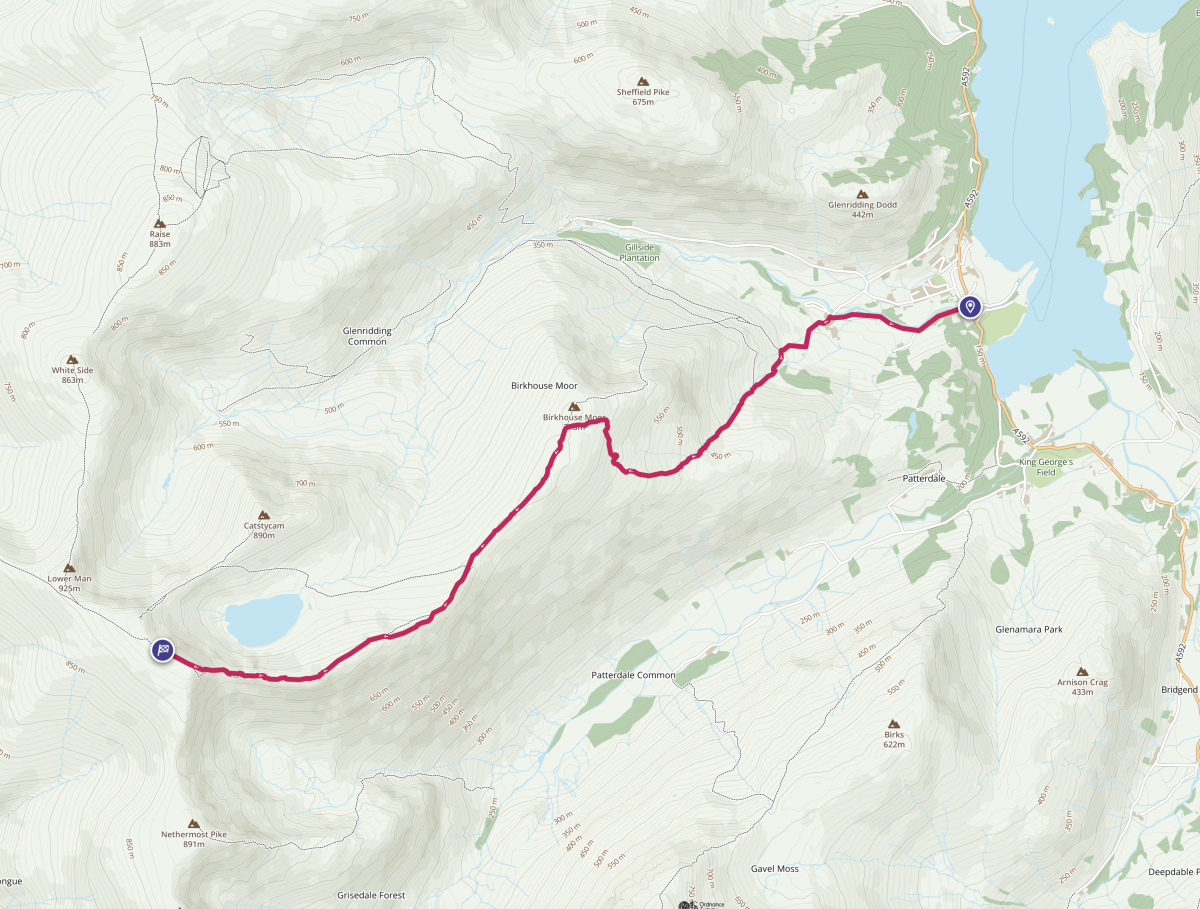
This is the most popular and busiest route to the top of Helvellyn. It takes in the iconic Striding Edge, making it the obvious choice for walkers who fancy an added challenge.
From Glenridding, take the road running between the village shops and Glenridding Beck. Bear right at a fork onto a riverside bridleway leading past Gillside campsite.
The track emerges onto the Greenside Road where a sign indicates the start of the Helvellyn path. Follow the footpath as it leads to a gate in the top intake wall which gives access to the open fellside below the steep northeast ridge of Birkhouse Moor. Turn left to take the pitched stone path climbing alongside Mires Beck. As you climb, don’t forget to turn around and take in the breathtaking views of Ullswater behind you. Eventually the path reaches the summit of Birkhouse Moor, 718m high, another Wainwright for the baggers. Follow the route as it runs alongside the stone wall to ‘Hole in the Wall’ – a landmark that signals the start of Helvellyn Striding Edge. From here the path begins to climb again up to the start of this iconic rocky ridge.
Approaching High Spying How, the highest point on Striding Edge, the path divides and you must decide whether to take the lower path which avoids the crest of Striding Edge, or not. If taking the higher path along the crest, there are five ‘towers’ to negotiate, jagged rocky outcrops with steep ascents and descents. The fifth tower, and the last one before the summit, is the most challenging. Finally, there’s a steep, rocky climb of around 120 metres up ‘The Castle’ to the summit plateau of Helvellyn itself.
You’ll eventually emerge on the flat summit of Helvellyn, so flat in fact that on the 23rd of December 1926 John Leeming and Bert Hinkler landed a plane right on the summit itself.
For the return walk, retrace your steps back along Striding Edge. Or for an alternative return, choose Swirral Edge instead along the opposite side of Red Tarn Helvellyn, a slight but worthwhile diversion that offers the opportunity to climb the distinctively coned Catstycam, or Catstye Cam. From here you can drop back down and take the path from Red Tarn to Birkhouse Moor to re-join the main path to Glenridding.
Option 2 – Helvellyn – Glenridding via Swirral Edge
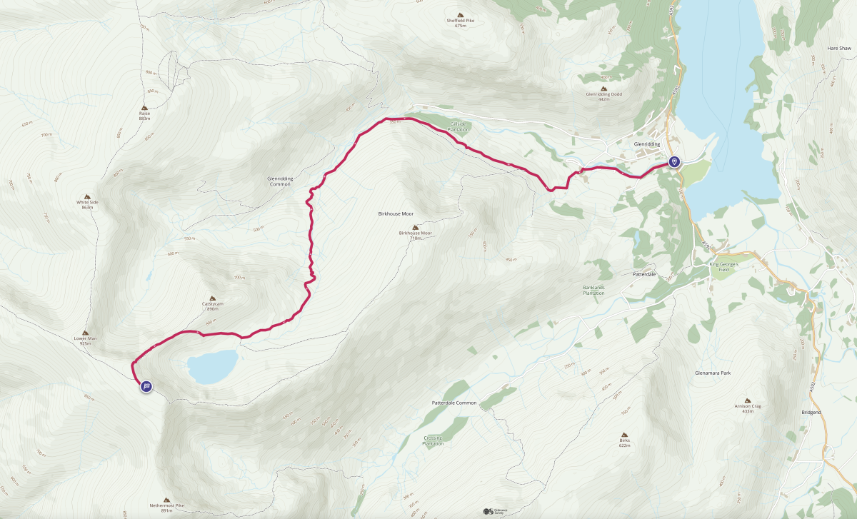
The route described below takes a wide sweeping circumvent of Birkhouse Moor through Glenridding Beck with some clear mountain pools to admire (or swim in) en route.
Alternatively, you can follow the route described above in Option 1 for Striding Edge and, just after the summit of Birkhouse Moor, take the path branching off on the right to Red Tarn. From the tarn you can pick up the main path to Swirral Edge.
From Glenridding take the road running between the village shops and Glenridding Beck. Bear right at a fork onto a riverside bridleway leading past Gillside campsite.
The track emerges onto the Greenside Road where a sign indicates the start of the Helvellyn climb. The footpath leads to a gate in the top intake wall which gives access to the open fellside below the steep northeast ridge of Birkhouse Moor. Unlike option 1 above, turn right from the gate here and follow the path contouring across the northwestern slopes of Birkhouse Moor. Make your way across the slopes and you’ll see the remains of the old Greenside Lead Mine to the right and below.
Stay on the path as it continues to curve around Birkhouse Moor. The pointed silhouette of Catstycam, or Catstye Cam, eventually comes into view. The path crosses a footbridge over Red Tarn Beck then begins to climb more steeply towards Red Tarn. As the path levels out on the approach to Red Tarn, beyond Helvellyn Swirral Edge, the summit comes into view. Just before reaching Red Tarn the path sweeps right and starts to climb once more towards Swirral Edge. Upon reaching the narrow ridge, it’s simply a matter of following the crest towards the summit. Swirral Edge is less frequently traversed than its flashier neighbour Striding Edge, but the views are no less impressive.
There are several rocky outcrops en route but nothing too challenging – and you’ll be treated to spectacular views across to Striding Edge opposite. The steepest part of Swirral Edge is the last part before the summit plateau, known as ‘The Fangs’.
From Helvellyn summit you can retrace your steps back along Swirral Edge or choose to return via Striding Edge if you’re feeling up to it, from which the main path heads over Birkhouse Moor summit and then descends back to Glenridding and your original Helvellyn start point.
Option 3 – Helvellyn – Glenridding via Raise, Whiteside and Lower Man
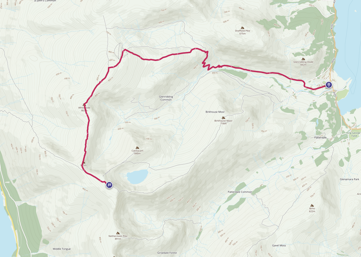
Our final Helvellyn Glenridding route approaches from the north, bagging two more Wainwrights en route, if you care about such things. Once again, we are starting in Glenridding village.
Unlike the first two options, this route leaves the village by Greenside Road passing the Travellers Rest Pub, NOT Gillside Campsite bridleway, and the lane that leads down to Rattlebeck Bridge and Gillside. The public road ends at High Rake Cottages and becomes a track. Continue past the cottages towards the old Greenside Mine. Pass through the old mine and its buildings. The paths to Sticks Pass, Kepple Cove and Helvellyn hike up a zigzag track below the stone-faced terrace and are well signposted. Above the terraces, the track continues towards Keppel Cove. The bridleway to Sticks Pass turns off to the right and climbs the steep slopes below Stang End in a series of wide switchbacks.
A while later you approach the course of the old smelting flue for the mine. After crossing the remains of the smelter flue it’s time to leave the Sticks Pass bridleway and follow the flue’s course across the slopes of Stang. The smelter flue, marked as ‘The Chimney’ on OS maps, is now almost completely collapsed after it fell into disuse over a hundred years ago.
Historically, it took the form of deep cutting into the bedrock, arched with stone and covered with soil and turf. It’s almost a mile long and terminates at a ruined vertical stack near the summit of Stang, approximately 335m above the smelter. When the flue was built in 1841 it was less than a ¼ of a mile long. In 1855 it was extended up to the summit of Stang. This longer flue not only carried the noxious fumes from the smelter further away from the valley, its snaking course and greater surface area afforded every opportunity for lead and silver particulates, which were suspended in the vapour, to condense. The flue was equipped with manholes at regular intervals and was swept periodically, the soot and condensed lead and silver being carried back to the smelt mill for reprocessing.
After following the flue to the summit of Stang, go past the ruined chimney stack to follow a faint path to climb the east ridge up to Raise summit, 883m high. The top of the Lake District Ski Club’s ski tow on Raise comes into view beyond, which lies the summit of Raise. From the summit cairn it’s simply a matter of turning south and heading along the very obvious and well-used ridge path onto Whiteside (863m high), then Lower Man (925m high), followed by Helvellyn itself, enjoying magnificent views as you go.
For a more direct descent back to Glenridding return via your choice of Swirral or Striding Edge.
Helvellyn from Thirlmere
Option 4 – Helvellyn – Thirlmere from Swirls via Lower Man
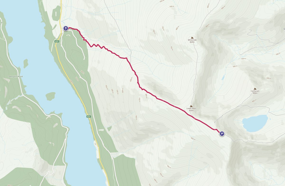
This is the most straightforward route to climb Helvellyn, approaching the summit from the grassy western side and avoiding the drama of the jagged eastern slopes, which you still get to admire once you reach the summit. The route is via an easy-to-follow pitched stone path which begins in Swirls Car Park on the A591 about halfway down Thirlmere Reservoir.
At the back of the car park, cross the footbridge over the stream and follow the footpath to Stanah and Helvellyn. Just before a stone wall, the path to Helvelyyn branches off to the left, crosses a small footbridge then continues climbing the open fellside. Another bridge re-crosses Helvellyn Ghyll, then the path begins to zig-zag as it climbs, and you’ll be treated to some spectacular views. In particular, north towards Skiddaw and east across Thirlmere, towards Great Gable and Pillar in the distance look incredible from this Helvellyn elevation.
The path ascends to Brown Cove Crags which are prominent above you and once reached, the gradient (thankfully) begins to ease. If you wish, you can take a slight detour to the summit of Helvellyn Lower Man, 925m, otherwise stay on the wide, very obvious path as it makes its way towards the summit plateau of Helvellyn.
At the summit you’ll be treated to breathtaking views of Striding Edge, Swirral Edge and Red Tarn below. Wainwright hunters can take a leisurely stroll south along the summit plateau to the summit of Nethermost Pike, 891m, before heading back to Helvellyn and retracing their steps back to Swirls Car Park.
Option 5 – Helvellyn – Thirlmere from Dunmail Raise via Dollywagon Pike and Nethermost Pike
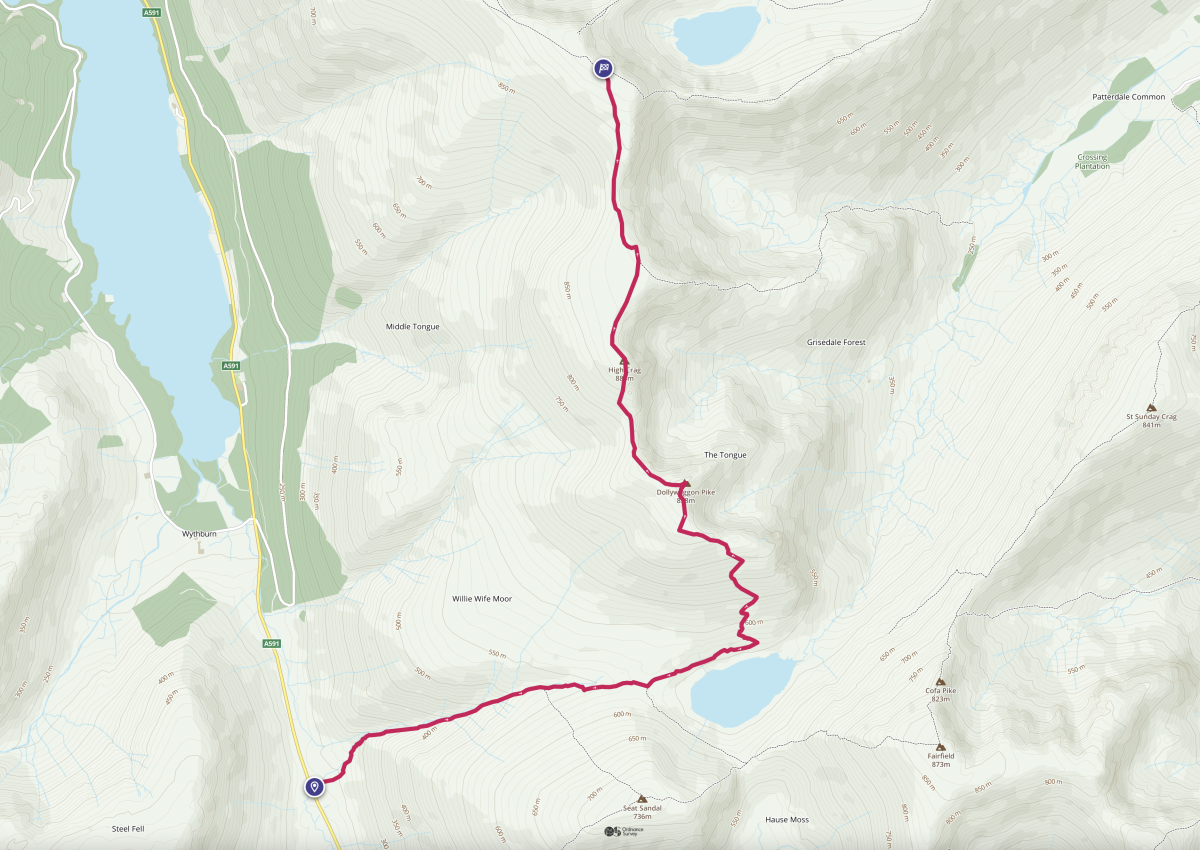
Our last route starts at the layby on Dunmail Raise, the highest point on the A591 between Grasmere and Keswick and takes in three Wainwright summits, including Helvellyn.
From the layby, head northwest towards Raise Beck – an obvious gully in the fellside. The stone path follows the beck all the way up to the striking and beautifully lonely Grisedale Tarn, not to be confused with Grizedale Tarn, located in Grizedale Forest.
After admiring the tarn for a few moments, or possibly stopping for snacks (we certainly did), take the path to the left of and above the tarn. This then meets up with another path before heading north and zigzagging up the mountainside towards the summit of Dollywagon Pike, at 858m high. Once you’ve reached the summit of Dollywagon, the hardest part of the walk is over. What remains is a stunning ridge walk north to Nethermost Pike, 891m high, to Helvellyn beyond with spectacular views everywhere you look.
Retrace your steps back to Dunmail Raise to end your Helvellyn walk from the same starting point.
Helvellyn Parking Options
There isn’t a specific Helvellyn car park, and the best parking options will be in either Glenridding or along the A591 which skirts the eastern edge of Thirlmere. The Helvellyn parking most suited to your hike will be the one closest to the start of the route you choose.
There is one main car park in Glenridding, so unless you have local accommodation with parking, you’ll have to pay for parking to climb Helvellyn. It’s £7 for 5 hours or if you want a bite to eat or to explore the village, £8.50 for 24 hours might be better (prices correct as of August 2025). Machines take cash, contactless or you can pay by app.
From the Thirlmere side, you can chance a free parking space along the A591 in the Dunmail Raise parking layby and pick route option number 5, or stick to option 4 and head to Swirls Car Park. Here you can pay by cash, contactless or app too and expect to pay £5.50 for a whole day. With 45 spaces, this car park can get busy so arrive early to avoid disappointment.
Best Places to Stay in the Lake District for Climbing Helvellyn
Look at any map of Helvellyn and you’ll see plenty of places to base yourself for exploring this awesome peak. But whether you’re here bagging Wainwrights or not, you shouldn’t limit yourself to just climbing one mountain when there are so many to enjoy.
We’d recommend staying in Langdale, away from the crowds and surrounded by the stunning Langdale Pikes. It’s roughly 30 minutes from Swirls Car Park, depending on where you stay, and we have some superb holiday cottages for you here.
Or if you’d like to immerse yourself in Lake District history, amenities and action, stay in Windermere or Lakeside and enjoy the drive to Glenridding through the beating heart of the Lakes. Each is less than an hour drive away and has plenty to see on the way. This journey to Glenridding will take you past Lake Windermere and high above Ullswater via Kirkstone Pass, before offering you glimpses of the southern end of the lake as you descend.
Holiday cottages in the Lake District give you the freedom to explore at your leisure – a space of your own to call home during your stay. However you decide to experience Helvellyn, retreat afterwards to a cosy cottage for a long hot soak in your hot tub and a cold drink to reward those weary feet. Check out our gorgeous locations to find your next home from home.
You might also like to check out our article about Coniston Old Man routes – just in case climbing Helvellyn isn’t enough!


